Atmospheric Predictions Help Emergency Managers Plan and Respond to Hazardous Material Threats
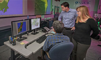
NARAC, the National Atmospheric Release Advisory Center, helps emergency managers protect the public by mapping the spread and risks of hazardous materials released into the atmosphere.
Harnessing the Power of Science and Technology
Founded during 1979’s Three Mile Island nuclear power plant accident, NARAC serves the nation by preparing for and responding to atmospheric releases that endanger the public and the environment. These threats include nuclear power plant accidents such as those at Chernobyl and Fukushima Dai-ichi, industrial chemical spills and fires, radiological incidents, and planetary mission launches involving radioactive materials. NARAC is one of Lawrence Livermore National Laboratory’s signature facilities, a showcase of our ability to harness the power of science and technology and multidisciplinary teams to confront critical, complex national security challenges.
Staff expertise in atmospheric dispersion, meteorology, hazardous material (radiological, chemical, biological, and nuclear) properties, physics, chemistry, health physics, numerical modeling, geographical information systems, computer science, software engineering, and computer graphics inform the center’s work.
Relationship to the Laboratory’s Security Mission
NARAC’s work supports several of Livermore’s national security missions, one of which is preventing and mitigating potentially catastrophic incidents involving radiological, chemical, biological, nuclear, or high-explosive materials. Its work is relevant to other Livermore missions, including addressing nonproliferation challenges, reducing the environmental impacts of energy use, and providing timely analytic and operational support to the Interagency Modeling and Atmospheric Assessment Center.
Plume Modeling and Analysis: Key Emergency Response Capabilities
One of the keys to effective response to an atmospheric release is to understand how the release will evolve, where the plume will travel, and what human exposure level may follow. NARAC can model and provide guidance to emergency operations staff tasked with responding to such emergencies. The center provides predictions and analyses to the Department of Energy/ National Nuclear Security Administration (DOE/NNSA) national operations center. Through DOE/NNSA, NARAC is the primary provider of radiological and nuclear plume modeling to the Department of Homeland Security–led Interagency Modeling and Atmospheric Assessment Center, whose role is to coordinate federal dispersion modeling and hazard prediction products during actual or potential incidents requiring federal coordination.
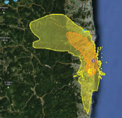
In 2011, NARAC was activated following the devastating earthquake and tsunami that damaged the Fukushima Dai-ichi Nuclear Power Plant in Japan. NARAC operated on a 24/7 basis for almost 4 weeks and provided daily weather forecasts and atmospheric transport predictions to inform planning for field monitoring operations and protective action planning.
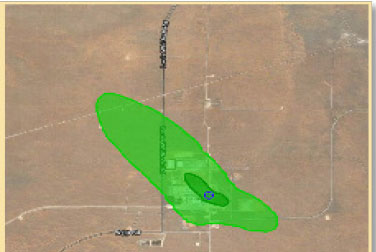
More recently, NARAC was activated by DOE in February 2014 in response to a release of transuranic radioactive material at the Waste Isolation Pilot Plant (WIPP) in New Mexico. Following an underground release, very small amounts of airborne radioactive material were detected by the plant’s stack exhaust and environmental air monitoring systems. NARAC plume model simulations based on detailed on-site meteorological data and WIPP-developed airborne radioactivity release estimates were used to estimate the low levels of on- and off-site dose and contamination levels. NARAC predictions were used as part of information provided to the public by DOE/WIPP about the consequences of this event.
Researchers and analysts at NARAC serve thousands of users at hundreds of federal, state, and local agencies, as well as emergency response teams, operations centers, and international organizations. In a typical year, the center fulfills thousands of airborne-plume simulation requests for emergency preparedness, participates in hundreds of major emergency response exercises, and responds to multiple incidents. The center maintains web sites through which authorized users can request, receive, and distribute plume predictions and share information during events.
Continuous Access to Modeling and Analysis For Users
Operating 24 hours a day, 7 days a week, NARAC can respond to multiple events taking place anywhere in the world. Its maps and graphics depict airborne and ground contamination areas; geographical features and building footprints; and estimates of casualties, fatalities, and damages from explosions. NARAC can also map areas exceeding dose and health effect levels of concern, and predict protective action guide areas for sheltering, evacuating, relocating the public, protecting workers, and controlling agricultural products.
Variety of Tools Empowers Emergency Responders
The center provides authorized users with high-fidelity modeling, analysis, and geographical information tools. NARAC’s data acquisition system and databases of global meteorological observations, weather-forecast model results, terrain elevation, land cover, population density, and maps feed a three-dimensional atmospheric flow and dispersion modeling system. Authorized users receive web browser access through which they can request, receive, and share NARAC predictions.
Using this platform, they also can perform fully automated simulations in minutes on Livermore’s computational hardware and software, and download stand-alone software to rapidly predict a plume’s dispersion on their own computers. The center’s staff provides quality assurance as well as detailed analyses, interpretation and training.


