Improving Searches for Radioactive Materials in Urban Areas
The Optimization Planning Tool for Urban Search (OPTUS) helps search teams efficiently sweep an area to determine whether a potential radiological or nuclear threat is present.
Limited Time, High Stakes
As the availability of nuclear technologies, materials, and know-how continues to spread, nuclear proliferation challenges grow and evolve. In response, Lawrence Livermore scientists and engineers work closely with federal, state, and local agencies to develop technical solutions that can help prevent, monitor, and mitigate proliferation activities. The Optimization Planning Tool for Urban Search (OPTUS) is one technology under development that has significant potential for improving how investigative teams search for potentially dangerous materials in metropolitan areas.
Law enforcement and homeland security agencies typically need to ensure that an area is clear of radiological or nuclear threats under two conditions: when credible reason exists that a device may have been planted or as part of a general sweep in advance of a special event. For example, sweeps are routinely conducted for major sporting events, parades, political speeches, or a presidential inauguration. Conventional urban-search approaches, while effective, often result in the inefficient use of trained personnel and the available vehicle-mounted or human-portable radiation-detection equipment. In addition, search teams typically divide an area into sections and do their best to search their assigned portion under severe time constraints, leaving teams with uncertain confidence about the overall effectiveness of their efforts.
Software Improves Capability
OPTUS is being developed with support from the National Nuclear Security Administration’s Office of Defense Nuclear Nonproliferation Research and Development in collaboration with Lawrence Berkeley and Oak Ridge national laboratories and the Remote Sensing Laboratory at Andrews Air Force Base. The novel technology is designed to help search teams cover a designated urban area (for example, several square kilometers around a city center) more efficiently. The goal is to either find a stationary radioactive source or declare the area free of potential threats with a quantitative estimate of confidence.
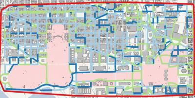
The OPTUS software program uses a family of Livermore-developed computationally efficient algorithms to optimize search assets within time restrictions. Maps of the area to be searched, background radiation readings, and other site-specific data are all uploaded into OPTUS. The software then assembles a model of the search area to define potential source and detector locations. This model includes the road network; metadata associated with individual road segments, such as road class or number of lanes; turn restrictions at intersections; and building locations and footprints.
When creating search models, OPTUS assumes the radioactive source is stationary and can be located anywhere in the outside search area. The software shows how to most efficiently search the prescribed area, given the number of available vehicles with radiation detectors and pedestrians equipped with handheld detectors. For vehicle- based searches, the software calculates turn-by-turn instructions that users upload to a navigation device such as a cell phone or laptop computer equipped with a global positioning system.
Building Confidence in Results
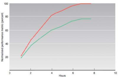
OPTUS provides a confidence level as to how effectively the search effort clears the designated area. A “coverage estimator” is computed and the results displayed by color-coding each possible source location corresponding to the confidence level that the source is not there. Initially, this calculation is done in advance of the search to explore optimal performance under various conditions and assumptions. During or after an actual search, OPTUS can estimate at any time the degree of clearing that has been achieved up to that point. The color-coded “heat map” can be updated to allow personnel to see the extent of the cleared area as the search proceeds.
Two Different Searches
Ultimately, OPTUS will be able to calculate the best plans for both wide-area exterior searches and those for high-interest locations. The first is done with vehicle-mounted detectors whose movement is constrained by the road network. Since vehicles must perform the search while following the flow of traffic, OPTUS optimizes both the number of times needed to traverse each road segment as well as the driving route to achieve those traversals. For example, a good route may revisit the hardest-toclear road segments multiple times while avoiding time-consuming left- and U-turns. The second search approach involves a closer pass of selected high-interest locations by an individual carrying a detector on foot or in an all-terrain vehicle. A high-interest location could be a building associated with a prominent special event or a venue that may be attractive to an adversary for staging, and ultimately detonating, a weapon. In addition, for high-interest locations that are searched by pedestrian teams, OPTUS can compute optimal “dwell” times at positions around the location to maximize the probability of detection given the total search time and the area.
More Secure Nation
Technologies such as OPTUS are certain to make searches for radioactive materials more efficient and cost effective. OPTUS also showcases Livermore’s ongoing efforts to strengthen capabilities for guarding against the use of weapons of mass destruction by either terrorists or a rogue nation. The novel software is also one example of how the Laboratory understands customer needs, applies relevant technologies, and partners with other institutions to meet the demands of national security.


